The Mississippi cut these bluffs out of windblown silt. The Loess Hills crest where the river bends, the bottomlands flood when the engineers say to, and the mounds were here longer than any of it. with a detour through the oxbows and earthworks the river carved around itself.
The route
 1Nature & Parks·NaturalTunica Hills Wildlife Management Area
Ice Age winds dropped loess — windblown silt — across the bluffs north of Baton Rouge, and when rain cuts through it you get something Louisiana almost never offers: 200 feet of elevation change in less than a mile. Tunica Hills Wildlife Management Area protects 6,500 acres of that terrain, and the ravines that result exist nowhere else in the state. The loess erodes into steep-walled hollows cool and damp enough to shelter copper iris and Florida anise, plants more at home in Appalachian coves than Gulf Coast floodplain. You are hiking through a biological outlier, a fragment of upland forest marooned by climate and geology in a state famous for being flat. The clay gets slick when wet. Wear boots with tread that bites, and pick up a self-clearing WMA permit before you go — Louisiana requires it for all wildlife management areas. The effort buys you the steepest trails in Louisiana and a chance to see what grows when the ground finally goes up instead of out.
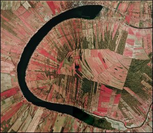 2Nature & Parks·NaturalFalse River
The Mississippi cut through its own meander sometime in the 1700s and left behind a twenty-three-mile crescent of still water. French settlers named it Faux Rivière—False River. The parish took its name from the severance: Pointe Coupee, cut point. What the river abandoned became one of Louisiana's most popular recreational lakes. People fish it. They ski it. The lakeside town of New Roads anchors the community and hosts an annual Mardi Gras. The lake that was never supposed to be a lake became the reason people stay. Go for the water. Ma Mama's on the Lake and Satterfield's are the dining stops that matter—places where the lake isn't just scenery, it's the premise.
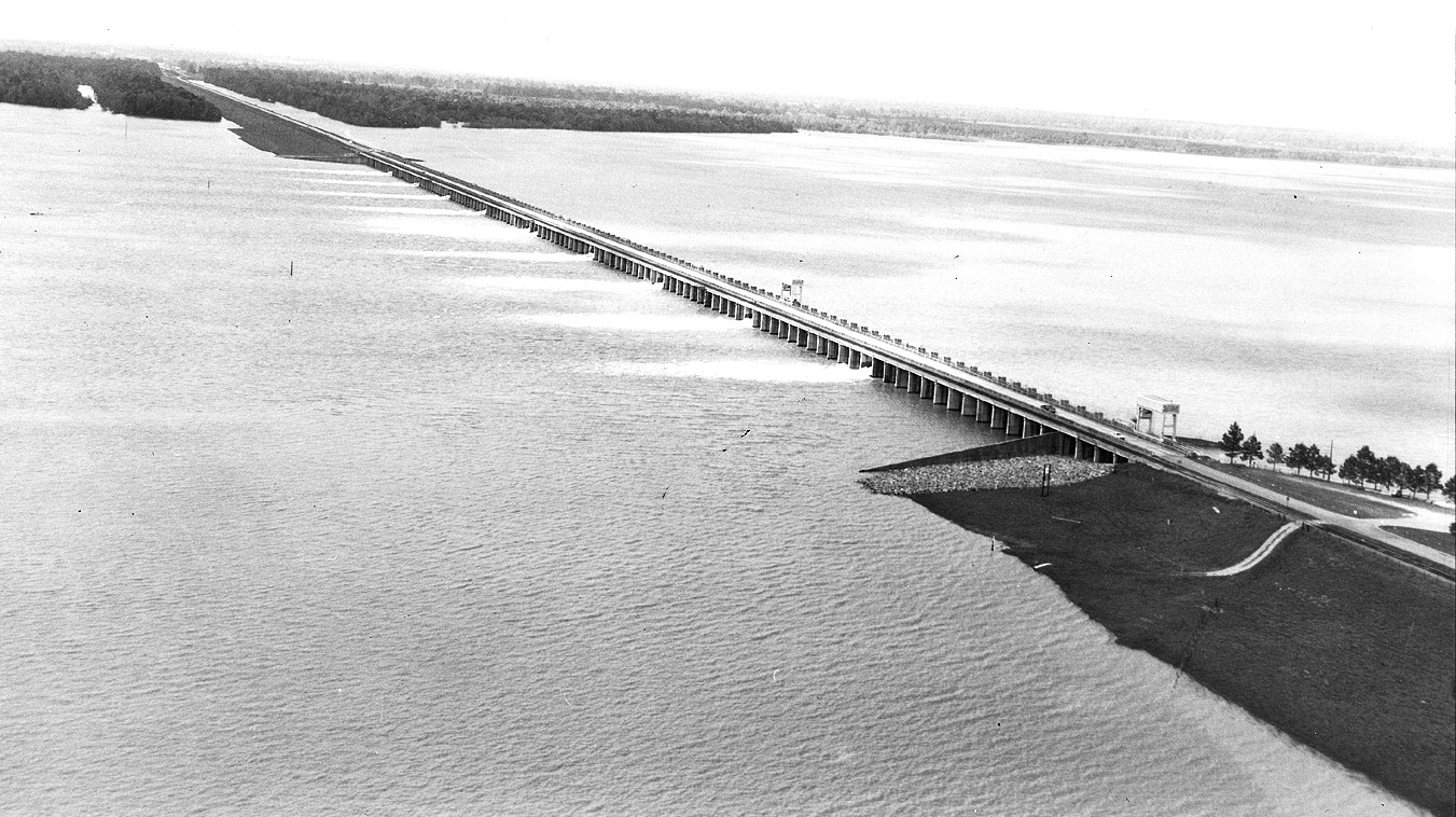 3Infrastructure·1954Morganza Floodway — The Last Resort
Twenty-seven years from authorization to completion — the Great Mississippi Flood of 1927 wrote the check, and the engineers didn't finish building until 1954. 125 concrete bays span nearly a mile of the Mississippi's west bank in Pointe Coupee Parish. The structure does one thing: when opened, it diverts floodwater west through the Atchafalaya Basin to the Gulf. Deliberately flooding rural land to protect cities. First opened May 14, 2011 — the only full opening in the structure's history. The Mississippi reached levels not recorded since 1927. The opening flooded approximately 4,600 square miles of rural Louisiana. Baton Rouge and New Orleans stayed dry. Morganza is one pillar of a three-part system. Old River Control Structure sits thirty miles north. Bonnet Carré Spillway sits 130 miles south. Together they manage what the river wants to do and where human settlement has decided it cannot go. The calculus is explicit: save the cities, sacrifice the basin. Visible from LA-1 near Morganza. Not a staffed visitor site, but the levees are publicly accessible. What you're looking at is the infrastructure that holds the answer to a question Louisiana has asked since 1927: who floods when the river insists.
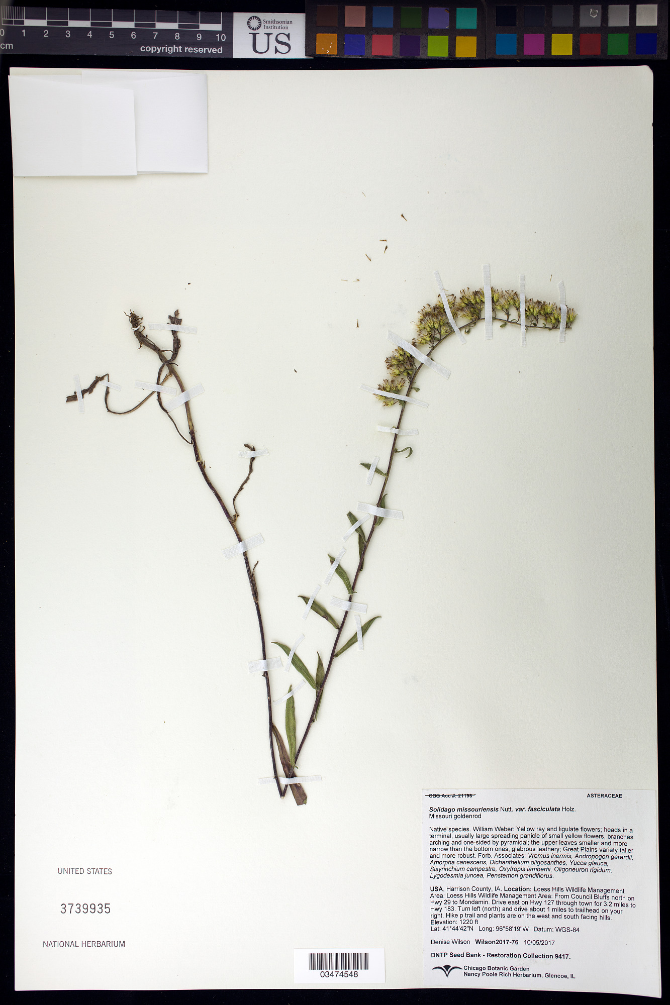
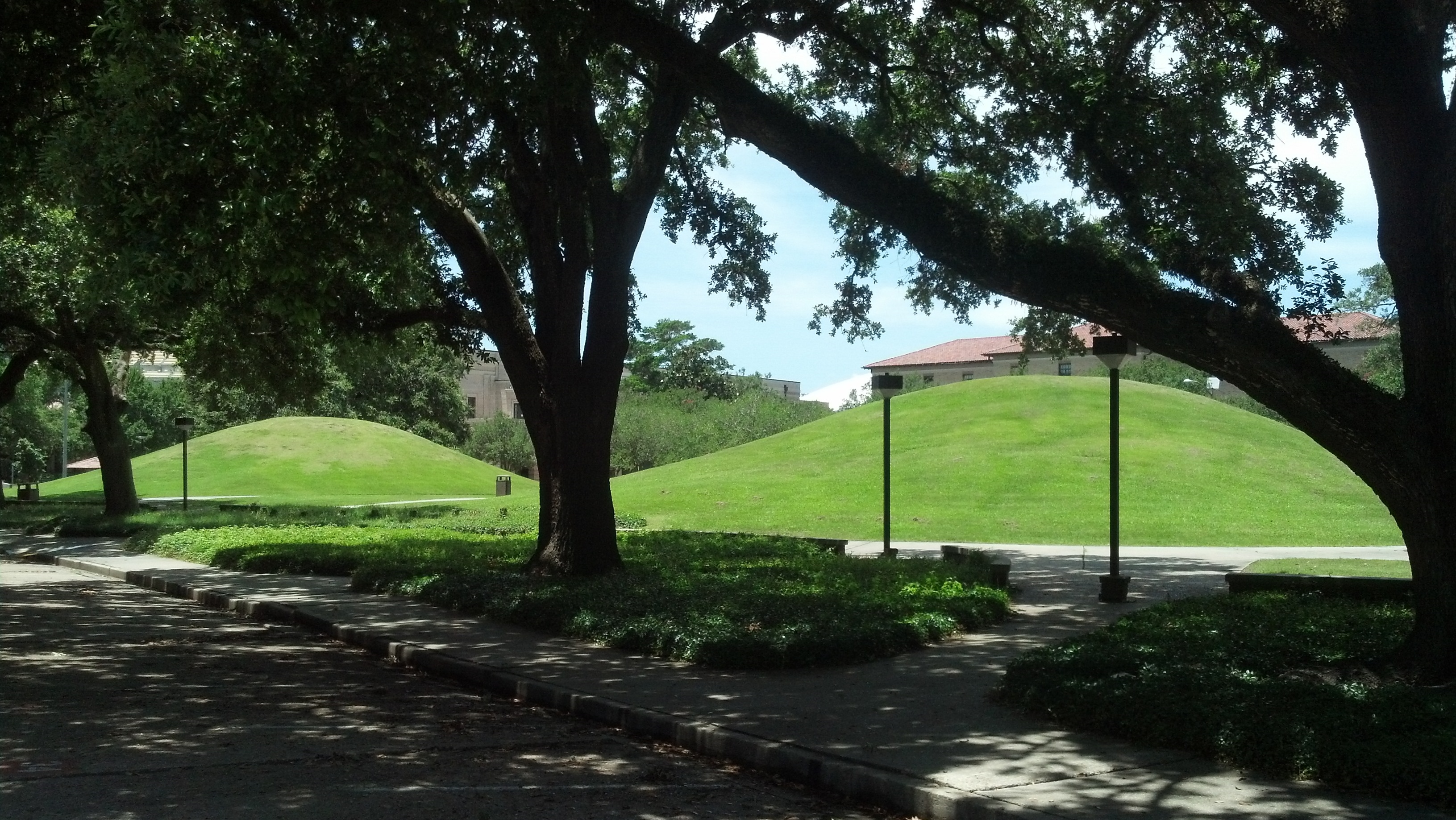 4Cultural Heritage·c. 3400–3000 BCE·NHLLSU Campus Mounds
Two earthwork mounds sit beside a football practice field on the LSU campus. Construction on the 20-foot-tall structures began more than 11,000 years ago and may have continued until 5,000 years ago — they predate the Great Pyramids of Egypt. The northern mound consists of hard clay dirt; the southern mound is more porous. Most students walk past them daily without knowing what they are. The scholarly consensus is that they were used for ceremonial and marking point purposes, rather than for burial. They are part of a larger, statewide system of mounds. In 2009, LSU professor Brooks Ellwood took core samples that revealed a layer of charcoal, possibly from a pit barbecue or a cremation. Based on his analysis, Ellwood conjectures that they contain cremated human remains and are substantially older than the existing consensus, as much as 11,300 years old. The builders are not directly connected to any modern tribal nation, making these among the more mysterious indigenous sites in Louisiana. Human habitation in the Baton Rouge area has been dated to about 8000 BC. Earthwork mounds were built by hunter-gatherer societies in the Middle Archaic period, from roughly the 4th millennium BC. By the time French explorer Sieur d'Iberville led an exploration party up the Mississippi River in 1699, many political centers were already in decline. The mounds stand as evidence of cultures that shaped this ground thousands of years before the red pole that gave the city its name. Due to their location in a heavily trafficked area of campus, the mounds began to show signs of degradation and natural erosion. The university installed a sidewalk between the mounds in 1985 and placed a low brick wall around them to prevent vehicles from crossing. In 1996, LSU Facility Services used river silt to patch damage on both mounds and seeded a hybrid Bermuda grass to prevent future problems. The mounds were listed on the National Register of Historic Places on March 1, 1999. While they were formerly used for tailgate parties, in 2010 they began to be fenced off during LSU's home football games to prevent them from being damaged. They are freely accessible south of the Quadrangle near Dalrymple Drive. No admission. Among the oldest known human-constructed features in North America, designated a National Historic Landmark.
 5Architecture·c. 1791·NRHPMagnolia Mound Plantation
A wooden house built around 1791 on a Spanish land grant, rising from the Istrouma Bluff above the Mississippi River before Louisiana was American ground. James Hillin, a Scots settler who arrived in 1786, lived here first with his wife Jane Stanley Hillin, five children, and six enslaved Africans named Thomas, John, Lucia, Catherine, Jenny, and Anna. On December 23, 1791, John Joyce from County Cork bought the 950 acres. When he drowned on May 9, 1798, sailing from New Orleans to Mobile, he held about 50 slaves cultivating indigo, tobacco, cotton, and sugarcane under an overseer. The widow Constance Rochon Joyce married Armand Duplantier, a former Continental Army captain under the Marquis de Lafayette. She brought 54 slaves from her estate to the marriage. From 1802 to 1805, they expanded the original four-room cottage to seven or eight rooms with a U-shaped gallery—a country house for a blended family with nine children between them. The hip roof covers everything: rooms, galleries, the life that happened underneath. In 1966, Baton Rouge bought the deteriorated property through eminent domain to preserve what had become one of the city's oldest surviving wooden buildings. The pigeonnier from around 1825 still stands. The overseer's house from around 1870 remains. In 1998, the city moved a double slave cabin from around 1830 onto the grounds—one half furnished as it would have been, the other holding an exhibit on slave life in Louisiana. The crop garden grows the same four cash crops once worked here. The open-hearth kitchen, reconstructed from archaeological evidence, holds spider pots, a clock-jack, sugar nips, waffle iron, and reflector ovens. Time a visit for a weekend hearth-cooking demonstration—the chance to see colonial Louisiana foodways practiced with fire and iron.
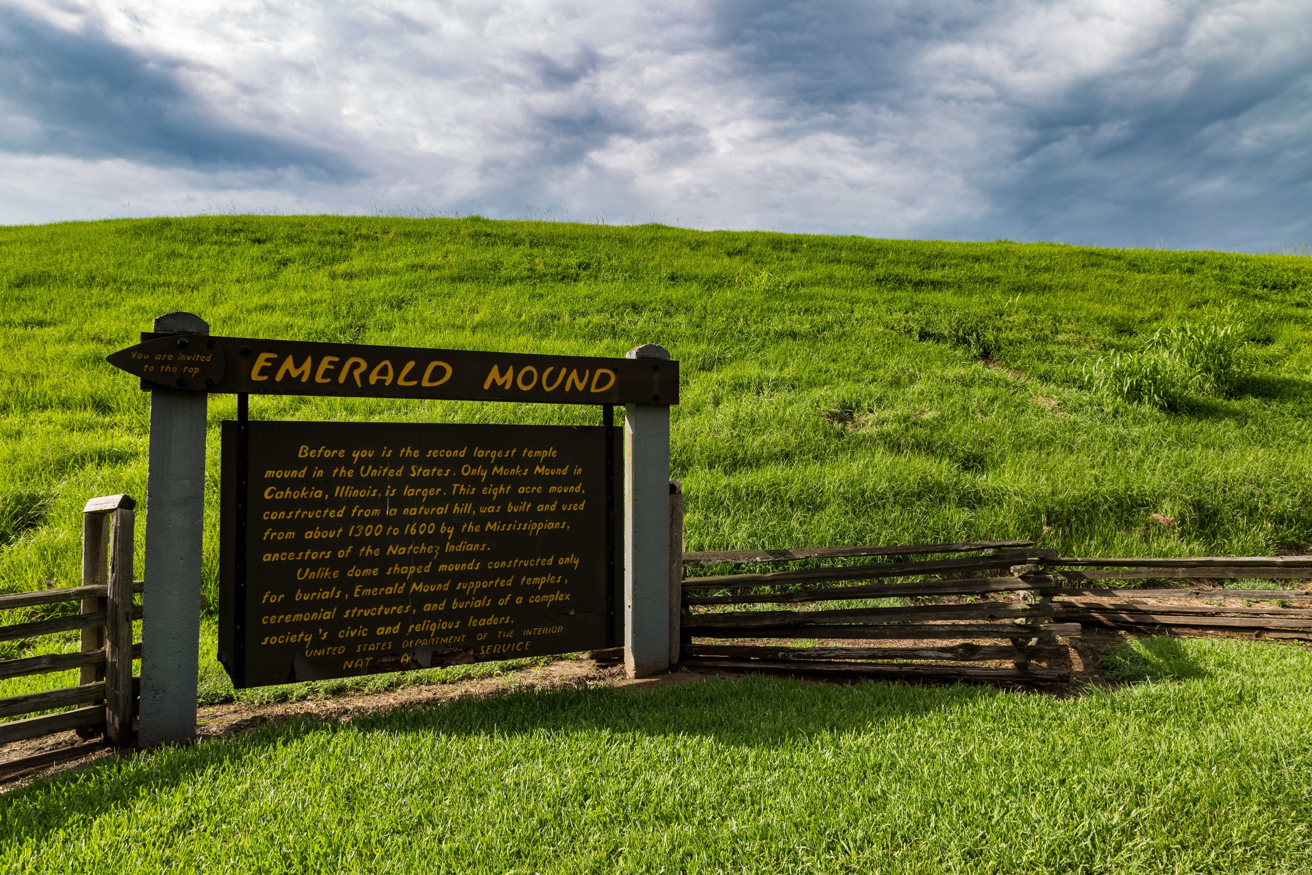 6Historic Site·1200–1600 CE·NHLEmerald Mound
Eight acres. A base 770 feet by 435 feet. Thirty-five feet high, topped by two smaller mounds that bring the summit to roughly sixty feet above the surrounding landscape. After Monks Mound at Cahokia, this is the second-largest ceremonial earthwork in the United States — and the Mississippian culture ancestors of the Natchez built it around a natural hill between 1200 and 1600 CE, depositing earth along the sides until they had reshaped the ground into an elongated, pentagonal-shaped, artificial plateau. The two secondary mounds on the summit are believed to be platforms for the homes of chiefs and other key leaders. The larger sits at the western end: 190 feet by 160 feet, thirty feet high. At its height, Emerald was the center of religious and civic rituals for a population who lived in outlying villages and hamlets. The Natchez used Emerald as their main ceremonial center at the time of first European contact. By the time of the La Salle Expedition of 1682, the tribe's main ceremonial center had moved to the Grand Village of the Natchez, twelve miles to the southwest. Six smaller mounds once flanked the edges of the primary mound, three on either side. A constructed ditch originally encircled the entire complex. Both were lost to erosion and plowing in the nineteenth century, when the site took its name from the Emerald Plantation that surrounded it. The National Park Service stabilized the mound in 1955 and declared it a National Historic Landmark in 1989. It is managed now by the Natchez Trace Parkway unit. Free and open dawn to dusk at milepost 10.3. You can walk to the top.
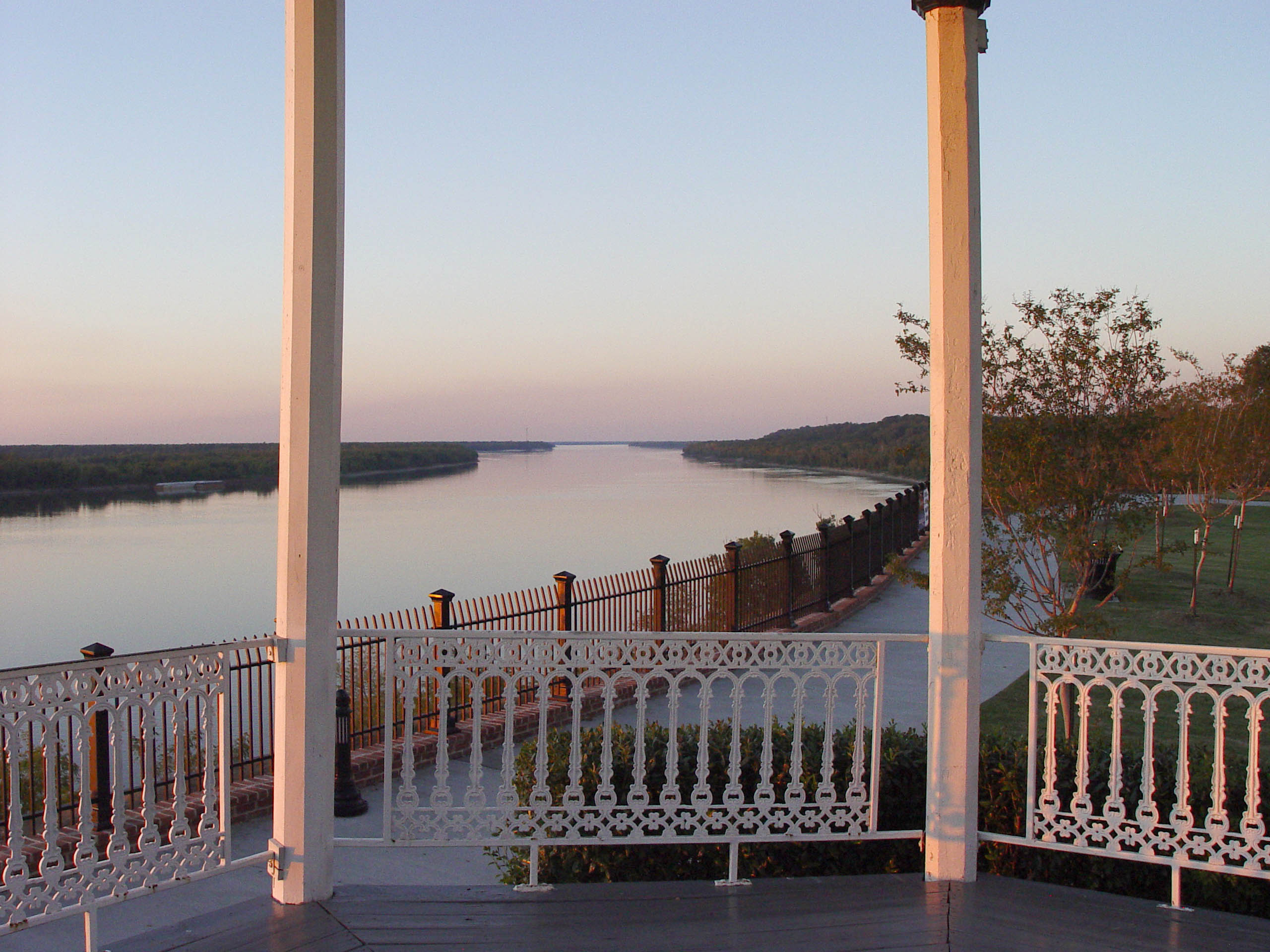 7Nature & Parks·operatingNatchez Bluff Park
Four flags, one bluff, one river. The French built Fort Rosalie here in 1716. The British renamed it Fort Panmure after they took possession following the Seven Years' War. The Spanish held it. The Americans inherited it. What they were all watching was this 200-foot bluff — the vantage point that made Natchez strategically critical. From here you could see everything moving on the Mississippi. Whoever held this height controlled river traffic. The fort fell into ruin. What remains is the bluff itself, now a city park with benches and gazebos along the edge. A walking path follows the rim. Louisiana is visible across the water. At sunset, the Mississippi from this spot is one of the signature experiences in Natchez — the reason people who know the city tell you to come here at that hour. Below the bluff was Natchez-Under-the-Hill, the landing site where the Natchez Trace began. The area was frequented by gamblers, river pirates, highwaymen, and prostitutes. In 1810 it was described as a place such that "for the size of it, there is not, perhaps in the world, a more dissipated spot." A Kentuckian who arrived that year stayed at a tavern aptly named The Kentuckian; he described the main room as "crowded in every corner...with sons of riot and dissipation." The respectable city moved uphill. The district that remains — roughly bounded by South Canal Street, Broadway, and the Mississippi River — was listed on the National Register in 1972. The park is free and open around the clock. Go at sunset if you can.