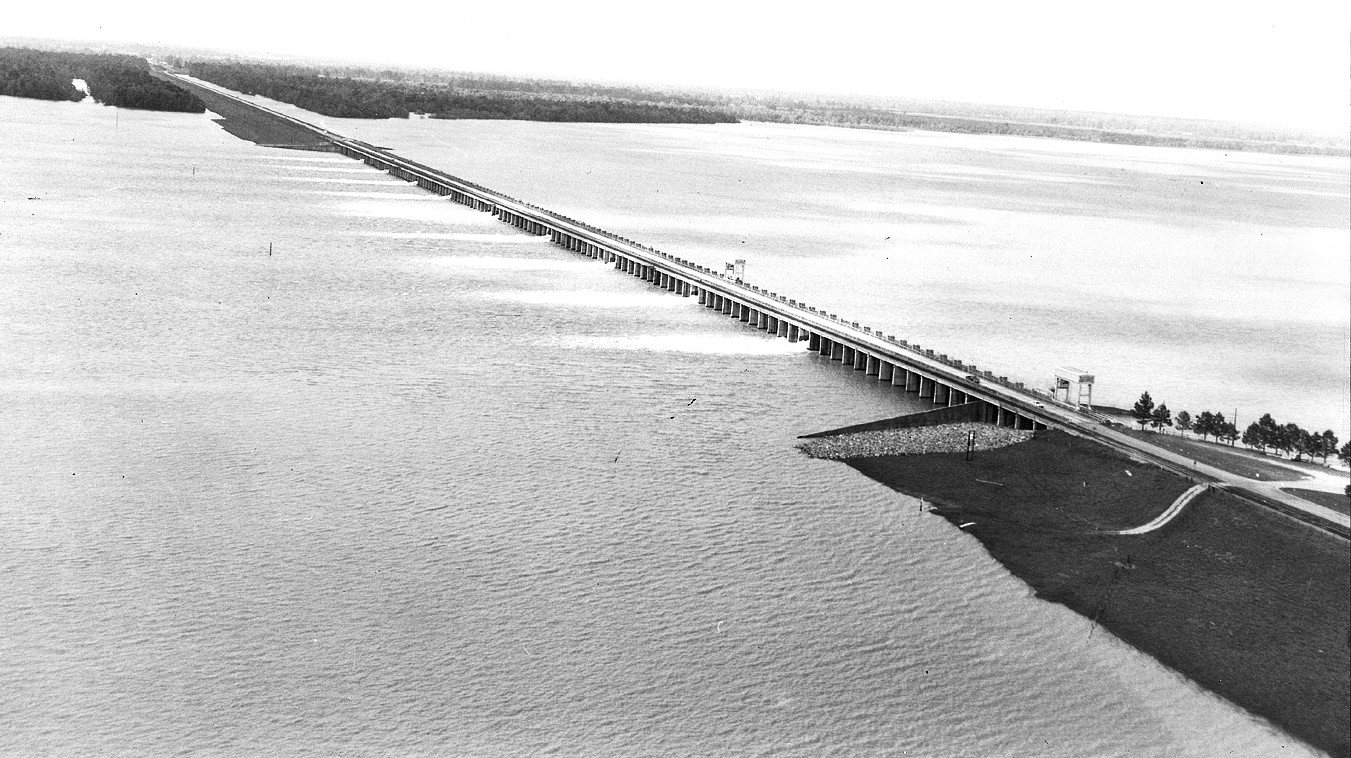
Twenty-seven years from authorization to completion — the Great Mississippi Flood of 1927 wrote the check, and the engineers didn't finish building until 1954. 125 concrete bays span nearly a mile of the Mississippi's west bank in Pointe Coupee Parish. The structure does one thing: when opened, it diverts floodwater west through the Atchafalaya Basin to the Gulf. Deliberately flooding rural land to protect cities. First opened May 14, 2011 — the only full opening in the structure's history. The Mississippi reached levels not recorded since 1927. The opening flooded approximately 4,600 square miles of rural Louisiana. Baton Rouge and New Orleans stayed dry. Morganza is one pillar of a three-part system. Old River Control Structure sits thirty miles north. Bonnet Carré Spillway sits 130 miles south. Together they manage what the river wants to do and where human settlement has decided it cannot go. The calculus is explicit: save the cities, sacrifice the basin. Visible from LA-1 near Morganza. Not a staffed visitor site, but the levees are publicly accessible. What you're looking at is the infrastructure that holds the answer to a question Louisiana has asked since 1927: who floods when the river insists.
- ·Authorized after the Great Mississippi Flood of 1927, completed in 1954 — 27 years of construction.
- ·125 concrete bays spanning nearly a mile of the Mississippi's west bank in Pointe Coupee Parish.
- ·When opened, it diverts floodwater west through the Atchafalaya Basin to the Gulf — deliberately flooding rural land to protect cities.
- ·First opened May 14, 2011 — the only full opening in the structure's history. The Mississippi was at levels not recorded since 1927.
- ·The 2011 opening flooded approximately 4,600 square miles of rural Louisiana. Baton Rouge and New Orleans stayed dry.
- ·Works in concert with Old River Control Structure (30 miles north) and Bonnet Carré Spillway (130 miles south) as the three pillars of lower Mississippi flood control.
- ·Visible from LA-1 near Morganza. Not a staffed visitor site, but the levees are publicly accessible.
Memories
Nearby

Editorial content compiled with AI assistance. Place details verified against public records.