Start at the Mill Mountain Star — 88 feet of neon erected in 1949, visible from 60 miles, the only municipal star this size in America. Climb the Parkway to Roanoke Mountain's overlook for the long valley view. Explore Park sits where the Blue Ridge meets the Roanoke River, with an early 1700s log cabin reassembled stick by stick. Carvins Cove closes the day: 12,463 acres of municipal park, 60 miles of trail, a 630-acre reservoir that doubles as the city's tap. The Parkway runs 469 miles. Roanoke is the southernmost city on it big enough to pull off.
The route
 1Cultural Heritage·1949Mill Mountain Star
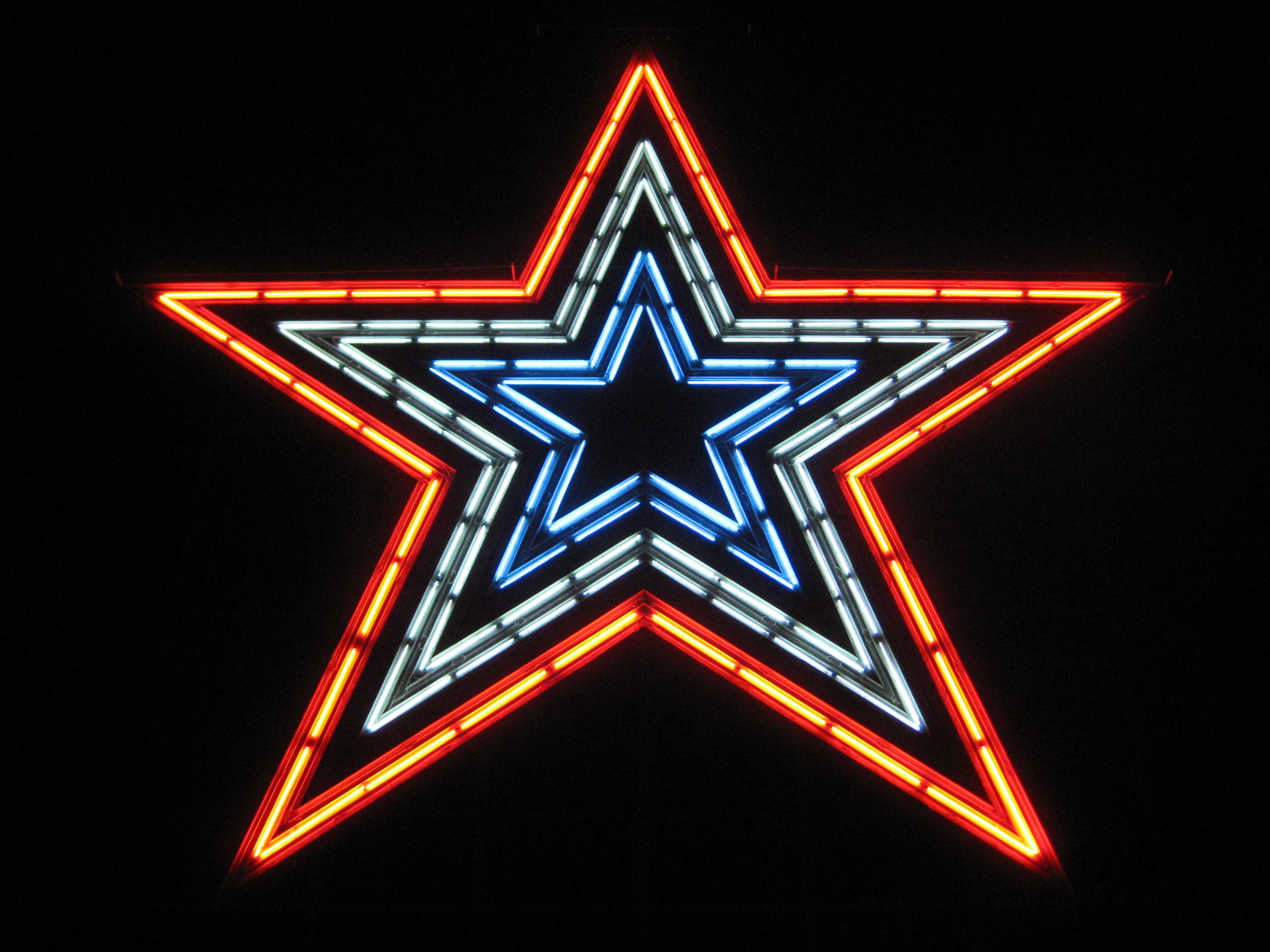
Roanoke in 1949 was a railroad town — the Norfolk and Western Railway had made the city its headquarters in 1882 and turned a village called Big Lick into Southwest Virginia's industrial hub. By mid-century the downtown merchants needed a gimmick to draw shoppers. They raised $28,000 and hired the Roy C. Kinsey Sign Company to build an 88.5-foot illuminated star on Mill Mountain, visible from downtown. It was supposed to be a Christmas promotion, lit for the holiday shopping season, then dismantled in January. The star went up on an eight-story steel tower weighing 60,000 pounds, mounted on a concrete base that used 500,000 pounds of concrete. Corning Glass Works manufactured 2,000 feet of neon tubing. On Thanksgiving Eve, November 23, 1949, Mayor A.R. Minton hit a dummy power switch for the cameras while Bob Kinsey threw the real switch from behind a circuit box. Former U.S. Congressman Clifton A. Woodrum spoke at the dedication and compared the star to the Star of Bethlehem, quoting the Book of Matthew: "When they saw the star they rejoiced with exceeding great joy." Actor John Payne, a Roanoke native who as a child had won the contest to name the Patrick Henry Hotel, attended. The star stayed. It was popular enough that the Merchants Association kept it lit year-round. The association paid the electric bill until 1955, when the city took over the cost. It is considered the largest free-standing, man-made, illuminated star in the world. On a clear night it is visible from 60 miles away. The star was originally lit entirely white. From 1957 until 1976, the city changed it to red for two nights to indicate a traffic fatality. It stayed red for three nights after the assassination of John F. Kennedy and for five after the Challenger disaster. In 1976, for the bicentennial, the design was changed to an outer red star encompassing inner double-stars of white and blue. After September 11, 2001, the star was kept in red, white, and blue for nearly six years. On April 22, 2007, officials changed it to all-white "as a symbol of healing and hope" after the Virginia Tech shooting. Red, white, and blue returned May 24, 2007 and remained until September 12, 2011. Since then it has stayed white except for Memorial Day, Flag Day, Independence Day, September 11, and Veterans Day. The star sits 846 feet above the Roanoke River. You can drive or hike to the Mill Mountain summit. The overlook is free. The Mill Mountain Zoo is adjacent. The star is the origin of Roanoke's nickname, "The Star City of the South." A 2021 city study found significant rust and damage to the anchors of the sheet metal base that hold the neon tubing, and the steel structure is covered in lead paint — $3 million to remove. As of 2023, the city was undecided on renovation or replacement, but no action would occur in time for the 75th anniversary in 2024. The star is difficult to maintain. It remains lit every night.
 2Nature & Parks·1936Blue Ridge Parkway — Roanoke Mountain
The 469-mile Blue Ridge Parkway threads the spine of the Blue Ridge from Shenandoah to the Smokies, and milepost 120 is the only place on the entire length where a one-way loop breaks from the main road. The Roanoke Mountain section spirals 3.7 miles over steep grades to a 2,161-foot summit, overlooks spaced every half mile. Towed vehicles are prohibited — the curves are tight, the pitch real. The road was authorized by Congress on June 30, 1936, after construction had already started the year before. Personnel from four Civilian Conservation Corps camps worked roadside plantings and graded slopes while private contractors laid the pavement. The Parkway has been the most visited unit in the National Park System every year since 1946 except four. There is no entrance fee. The speed limit never exceeds 45 mph. At milepost 129.6, the Roanoke Valley Overlook frames the largest city on the Parkway's route — the town that began as Big Lick, named for salt deposits that drew game, renamed when the Norfolk and Western Railway made it a boomtown in 1882. Down the ridge at milepost 114.9, a short walk reaches views of the Roanoke River Gorge. The Parkway Visitor Center is at milepost 115. Sunset from the Roanoke Mountain summit is the reason to drive the loop.
 3Nature & Parks·1999Explore Park
In 1882, the Norfolk and Western Railway chose a small town called Big Lick as its headquarters, and Roanoke boomed into existence — a city conjured by track and steam, its economy tied to what rolled on rails. When the railroad pulled out in 1982, the city had to invent new reasons for people to come. Explore Park is one answer to that question. The Virginia Recreational Facilities Authority acquired 1,100 acres in 1988 at milepost 115 on the Blue Ridge Parkway — 700 acres in Roanoke County, 400 in Bedford, near the gorge where the Roanoke River leaves the valley. The initial aim was to draw visitors driving on the Parkway to the Roanoke area. Early ideas included an expanded Mill Mountain Zoo and a Lewis and Clark theme park. A lack of investment funds led the park to become a more modest living history museum focused on the early history of Southwest Virginia. Reconstruction began on the 1837 Hofauger House in September 1991. The park opened to the public July 2, 1994. Between 1991 and 2002, the park added relocated historical structures: the Brugh Tavern, which opened April 28, 1998, as a restaurant following an investment of $1,400,000; Slone's Grist Mill, which opened September 20, 2002, following an investment of $330,000; Mountain Union Church; and a reconstructed Totero Village patterned after a late 17th-century Native American settlement. By 2008, Explore Park had received investment at the federal, state, and local levels totaling nearly $52,000,000. The park did not reopen for the 2008 season after the 2007 season ended November 18. It transitioned to a passive recreation facility July 1, 2008, and the buildings were shuttered except for the Blue Ridge Parkway Visitor Center. In October 2013, the park reopened under a 99-year operating lease to Roanoke County. Annual visitors increased from 13,000 or fewer in 2012 and 2013 to more than 18,000 in 2014, the first full year under county management. The historical area is not normally publicly accessible. Mountain Union Church may be rented for weddings. The park now offers mountain biking, hiking, zip lines, kayaking, and treetop adventure courses. The mountain bike trails connect directly to the Roanoke Valley greenway system. Some activities require reservations and fees. Open seasonally.
 4Nature & Parks·1947Carvins Cove Natural Reserve
In the 1930s, the City of Roanoke dammed Carvins Creek and drowned a rural community to secure its drinking water. The reservoir that swallowed the hamlet of Carvins Cove now anchors 12,700 acres of municipal forest—the fifth-largest city park in the United States and the second-largest managed by a municipality. During droughts, the old roads and housing foundations reappear. Roanoke spent the 20th century annexing its way out of the county, and the water system followed the same logic: consolidation. After droughts in the late 1990s, the city and Roanoke County created the Western Virginia Water Authority, which now owns the 630-acre reservoir and everything below the 1,200-foot contour. The city owns the ridgeline above. In 2008, Roanoke placed 6,185 acres under a conservation easement—the largest ever recorded in Virginia—donated to the Western Virginia Land Trust and the Virginia Outdoors Foundation. Development stopped at the waterline. What that leaves is 60-plus miles of trail and a backyard trail system mountain bikers treat like public infrastructure. The XXC endurance race covers 43 miles and climbs over 6,000 feet. Some downhill runs are expert-level only and drop more than 1,000 feet from ridge to reservoir. Hikers can disappear for an entire day without crossing a road. The main ridgeline of Brushy Mountain rises about 1,200 feet above the waterline. The boat launch opens in April. Electric motors only—the fear of zebra mussels drove the city to restrict access in the early 1990s. Entry is free. Multiple trailheads off Carvins Cove Road.